Group
Leister logoLeister logo

North Greenland Expeditions 2021 and 2022

Christiane Leister, in a red jacket, gray pants, and boots, stands on a vast, flat expanse of sea ice. Patches of open water and distant ice floes are visible under a pale blue sky.
In July 2021, researchers from Denmark and Switzerland discovered what was thought to be the world's northernmost island during the Leister Around North Greenland expedition. During the subsequent Leister expedition Go North in August 2022, another team of researchers discovered that the island is a stranded iceberg.

Author: Silke Landtwing, Corporate Communication Manager, Leister Switzerland

Images and video: © Christiane Leister


In the summer of 2021, a Swiss-Danish research team set out on the Leister Around North Greenland Expedition, initiated and funded via the Leister Foundation, to carry out scientific projects and visit the island of Oodaaq, discovered in 1978 and not sighted since 2008.

During their explorations, the researchers in the team together with Christiane Leister were unable to find Oodaaq, but they did come across an island about 30 by 60 meters in size that had not been charted before. They christened the new island with the Greenlandic name “Qeqertaq Avannarleq”, which means “northernmost island”. News of the discovery of the new northernmost island on our planet then quickly went around the world.

The new island was located about 800 meters north of the islet of Oodaaq, which until then had been considered the closest piece of land to the North Pole, thus becoming the northernmost point of the Greenlandic border. 

Christiane Leister, in outdoor clothing, kneels on a rocky, icy shore, touching a large rock. Behind them, sea ice and snow extend toward distant mountains under a clear sky.

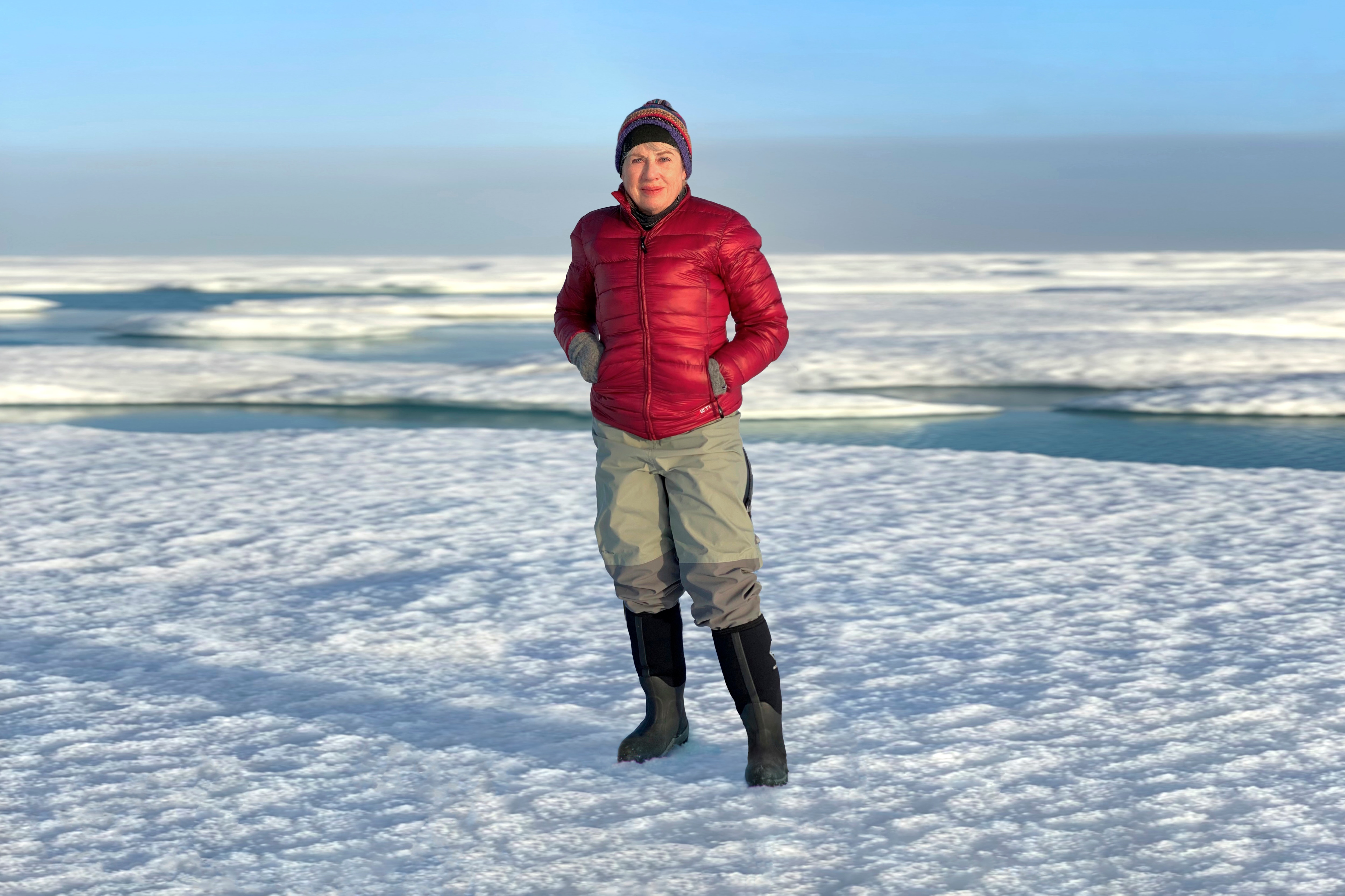
Christiane Leister in July 2021 on the newly discovered northernmost island “Qeqertaq Avannarleq”. In the foreground a large boulder under which an aluminum box containing the expedition data was deposited. Christiane Leister found this aluminum box again in August 2022 and moved it under a newly erected cairn.

“World's Northernmost Island” is in Fact a Stranded Iceberg

However, new findings of an interdisciplinary Swiss-Danish research team of the following expedition Leister Go North 2022 in August 2022 show that the supposed northernmost island “Qeqertaq Avannarleq” is a stranded iceberg with moraine material. Also Oodaaq and other small islands, which were discovered after 1978 and could not be identified after a few years, so-called “ghost islands”, were in fact icebergs. The icebergs broke off from glaciers on the Greenland mainland, covered with gravel and rock, and temporarily stranded on the bottom of the Arctic Ocean north of Greenland. According to Danish scientist Prof. René Forsberg (DTU Space, Technical University of Denmark), who was with the expedition, it is very likely that such icebergs will disappear in the future. When exactly they will have melted enough to move on, however, remains unclear, he said. The scientists believe that the origin of these icebergs lies with the glaciers west of Cape Morris Jesup and that there may be other stranded “iceberg islands” to discover in the future north of Greenland's coast.

An expansive glacier flows through a rugged mountain valley, with snow-covered peaks and ridges stretching into the distance. The glacier terminates in a partially frozen lake filled with floating ice chunks.

Glacier at Cape Christian IV, about 50 kilometers west of Cape Morris Jesup. This glacier and others in the nearby vicinity may be the origin of the stranded “iceberg islands”.

The Mystery of the Ghost Islands Revealed

Thus, the decades-old mystery about so-called “ghost islands” reported in the past has been solved with the help of new scientific findings. During the Leister Expedition Go North 2022, the researchers drilled about 30 boreholes through the ice in the Arctic Ocean north of Cape Morris Jesup to determine the sea depth with echosounder measurements. In addition, they measured the ice thickness, which was two to three meters. In addition, detailed GPS and lidar measurements were made to map the seafloor. According to René Forsberg, all the investigations confirmed that the islands discovered by the 2021 and 2022 Leister expeditions are located in a water depth of 25 to 45 meters. They are not connected to the seafloor and are consequently stranded icebergs, so-called “iceberg islands”.

Three people in cold-weather gear work on a snow-covered ice sheet. One kneels with equipment, another stands holding a long measuring rod, and the third sits nearby. A helicopter is parked in the background, and scientific instruments are scattered on the ice.

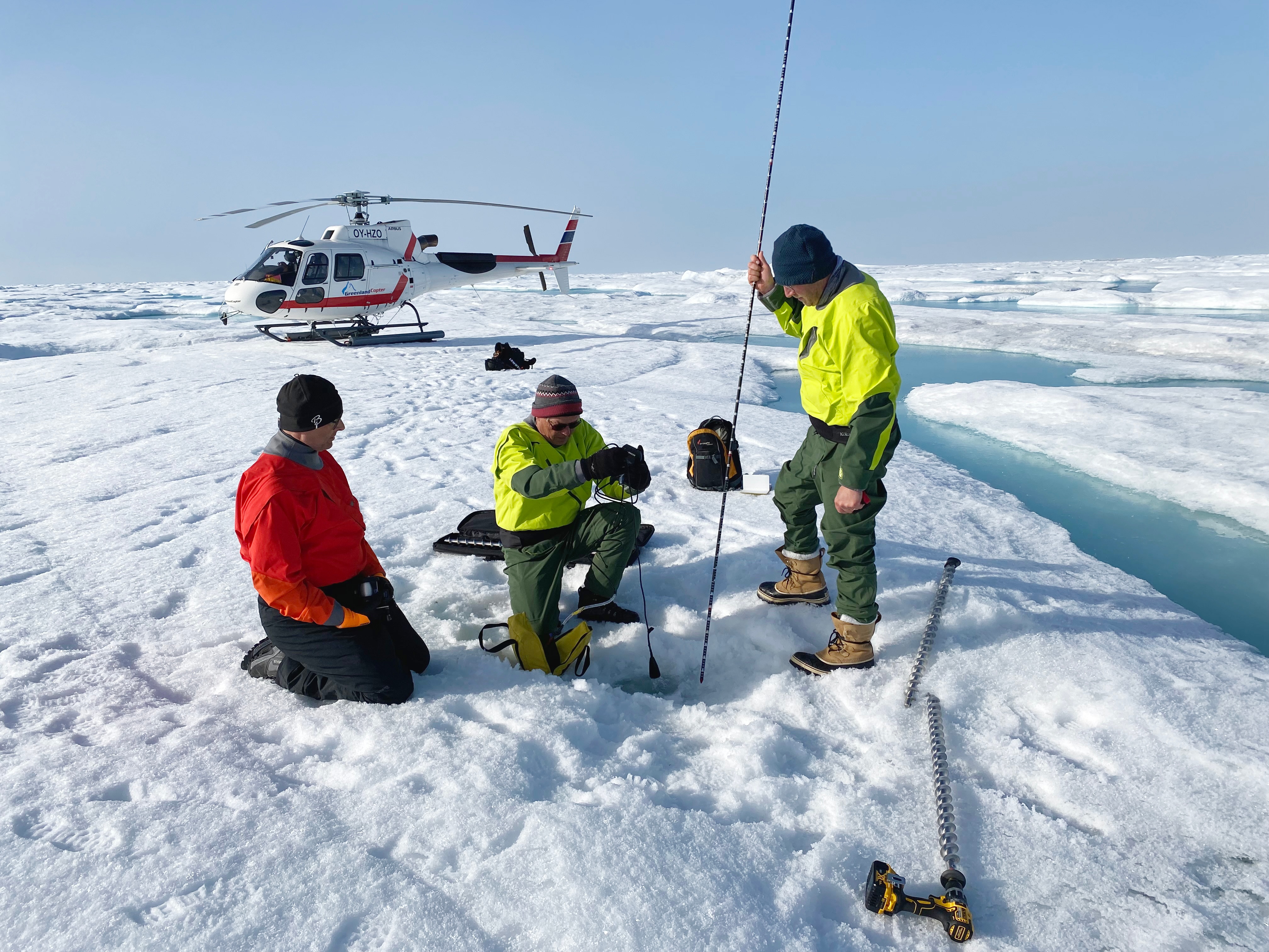
The picture shows René Forsberg, Martin Nissen (Danish Agency for Data Supply and Efficiency), and Henrik Lassen (logistics manager of the expedition) drilling the ice. René Forsberg measures the sea depth with an echo sounder and Martin Nissen the thickness of the fast ice with a probe.

New Island Discovered

Christiane Leister, dressed in a red jacket and winter gear, kneels beside a small pile of rocks on rocky ground. Snow-covered mountains and glaciers stretch across the background under a partly cloudy sky.

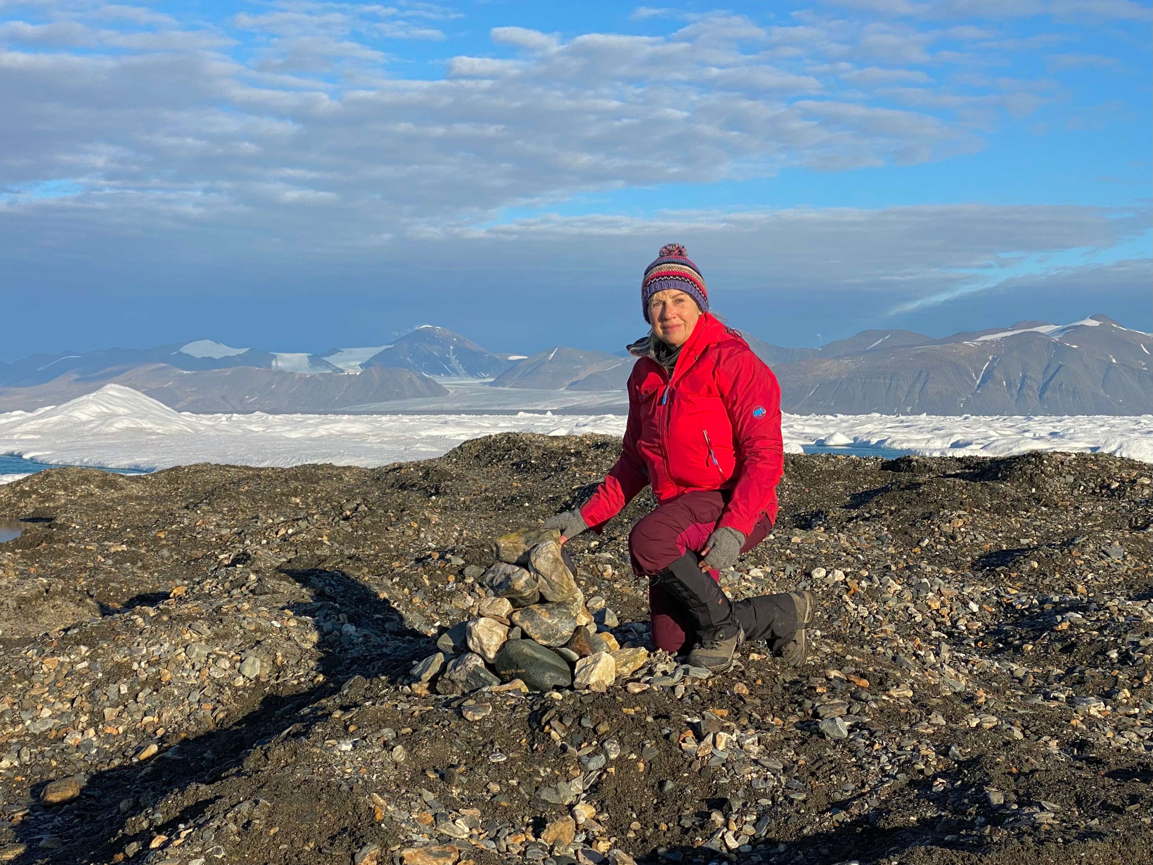
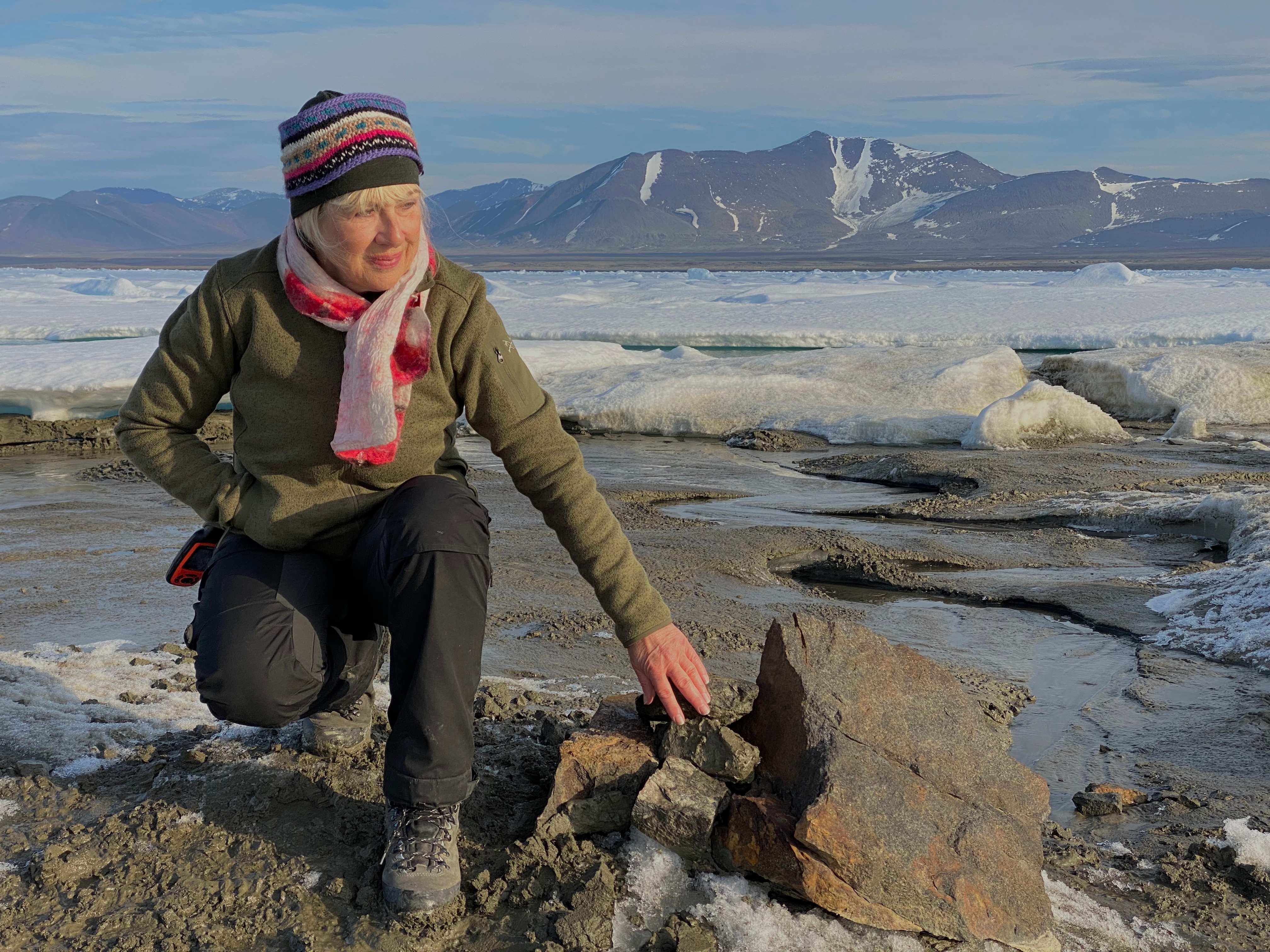
Christiane Leister on the island, newly discovered in August 2022. In the foreground is a cairn, under which is an aluminum box with the expedition data. In the background the fast ice and the North Greenlandic coast with mountains and glaciers.

During work on the fast ice, another small “iceberg island” was discovered east of Kaffeklubben by the Leister Expedition Go North 2022. It has an extension of about 50 by 40 meters and is completely covered with rock material. Like all other “ghost islands”, this “iceberg island” will also disappear from the scene one day. The two “Leister Islands 2021 and 2022” are currently the only ones that have been sighted by expedition participants in the Arctic Ocean north of Cape Morris Jesup. If and when they will disappear or if they will get company from other “iceberg islands” is not predictable.

Scientists on the Leister Islands

To gain further scientific insights into the origin of the stranded “iceberg islands”, the scientists visited the “Leister Islands” discovered in 2021 and 2022. They took various soil samples for the examination of bacteria, rock material for geological determinations and water samples for isotope analyses.

Four individuals in cold-weather clothing stand together on a snow-covered, icy surface. Two plastic containers with labels are placed on the ground in front of them, and a helicopter is parked in the distance.

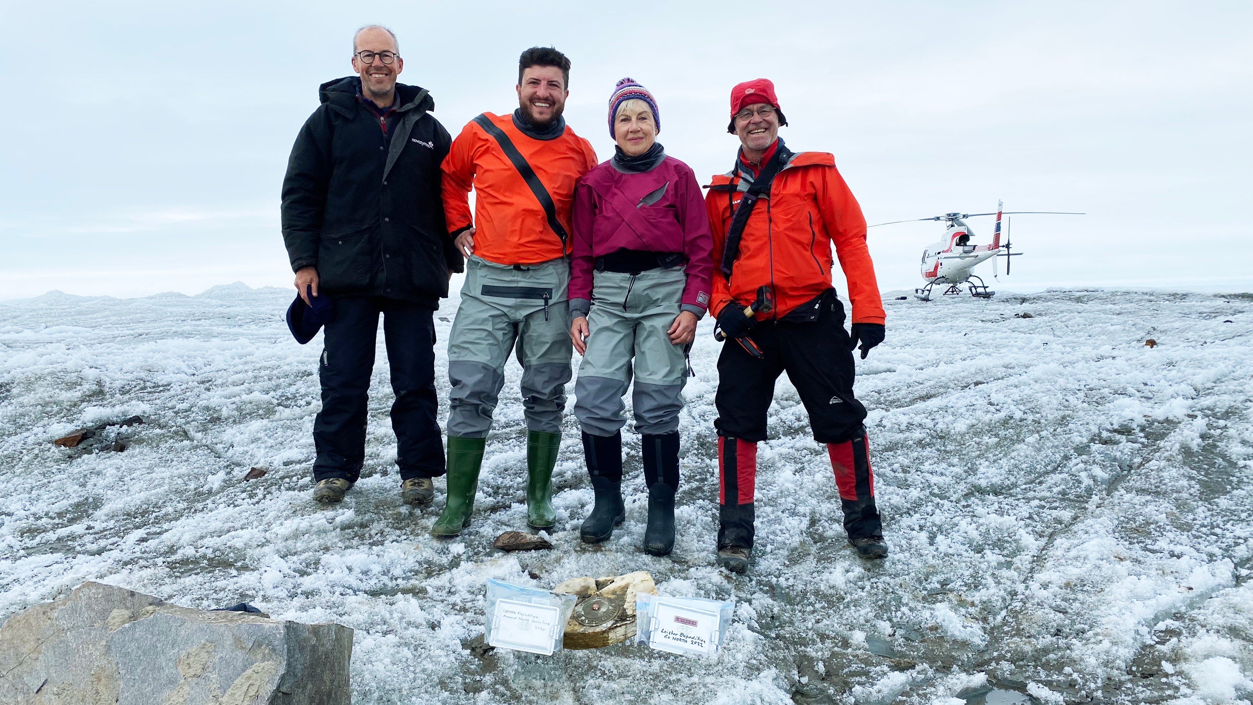
Christiane Leister with the scientists Prof. Anders Primé (University of Copenhagen), Dr. Tobias Schneider (Columbia Climate School, New York,) and Dr. Denis Schlatter (Swiss geologist) on the island discovered in 2021, which they christened “Qeqertaq Avannarleq”. In the foreground, you see a geomark and two aluminum boxes with the expedition dates 2021 and 2022, which were subsequently deposited under a newly erected cairn.

A person in a dark winter coat and hat crouches on icy ground near the edge of a body of water, using a tool to collect a sample. Large chunks of floating ice are visible in the water behind them.

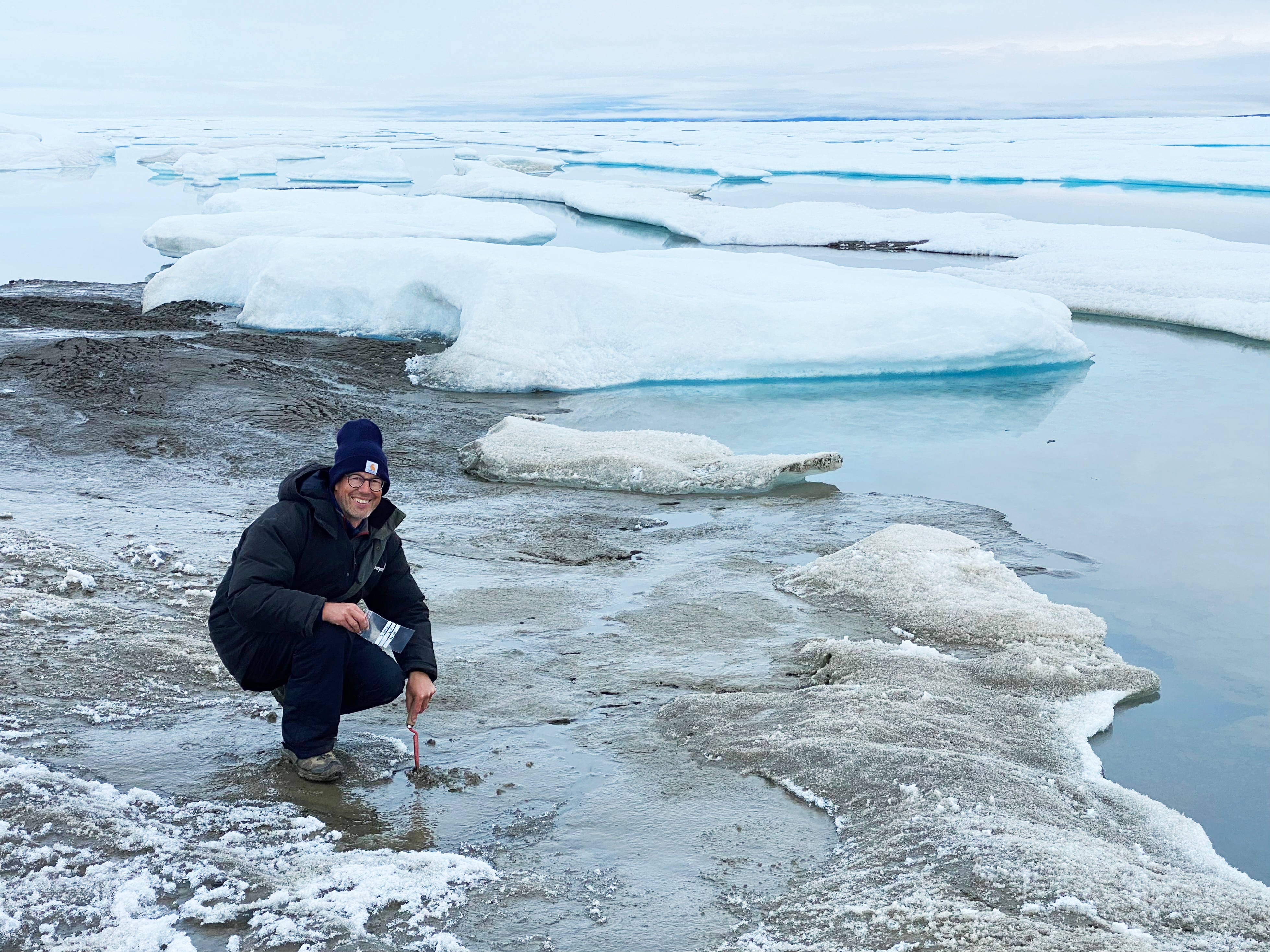
Aders Primé, while taking various soil samples to determine bacteria on “Leister Island 2021”. The prepared samples will later be examined in the laboratory for origin and properties.

A person in a red jacket and winter gear leans over a large rock on a snow-dusted, rocky shoreline. The background features floating sea ice and a calm, icy expanse of water.

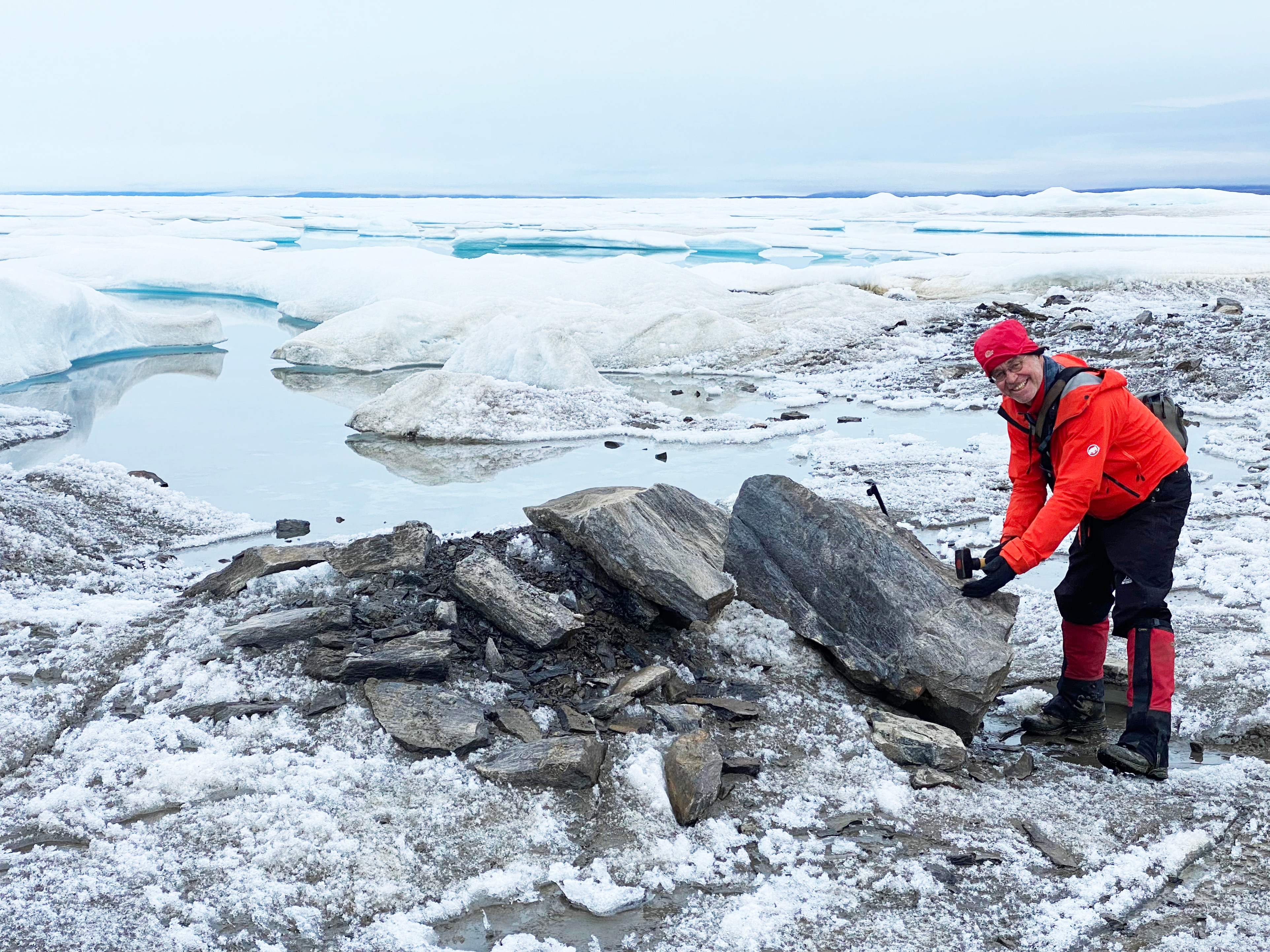
Denis Schlatter is pleased to see large boulders on the “Leister Island 2021”, enough material for samples for subsequent geological examination in the laboratory of the University of Karlsruhe.


Two individuals dressed in red cold-weather gear kneel on rocky ground beside a shallow pool of water. Snow and ice formations are visible in the background, and both are reaching toward the water, with their reflections visible on the surface.

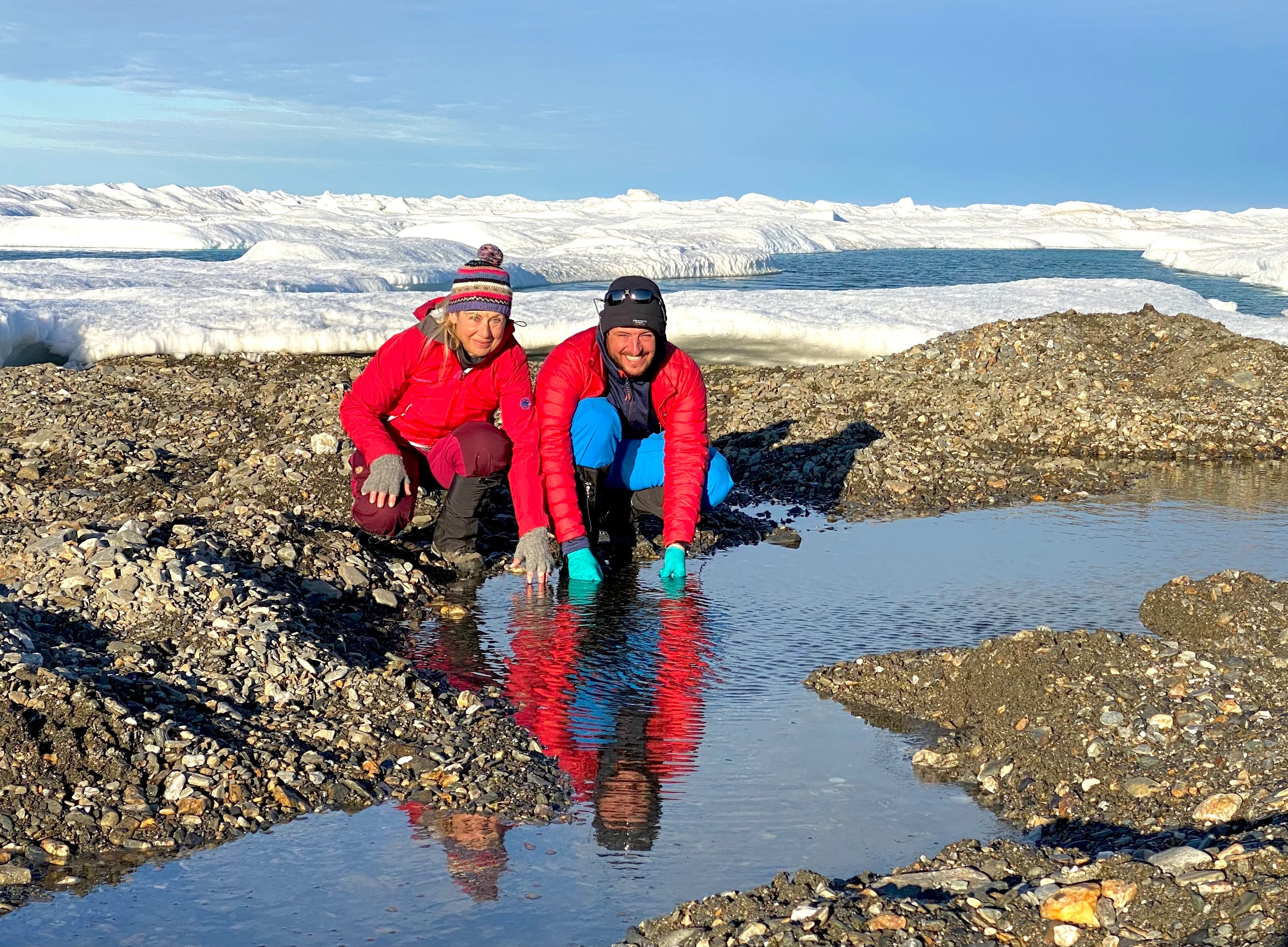
Christiane Leister and Tobias Schneider are on the newly discovered “Leister Island 2022,” taking water samples for isotope analysis.

Kaffeklubben on New Greenland Maps as Northernmost Island in the World

A large, dark landmass emerges from a vast expanse of broken sea ice and open water. The island is mostly barren, with patches of snow and ice along its edges, and low clouds or fog hover above the horizon.

Here you see an aerial view of Kaffeklubben Island. In the distance (at the top of the image) between fast ice and sea ice, an open water belt is visible as a blue stripe.

After Oodaaq turned out to be a stranded iceberg according to new findings, the island of Inuit Qeqertaat, also known as Kaffeklubben Island, is again considered the northernmost island in the world as well as the new border of Greenland.

The stranded icebergs, which include the “Leister Islands” discovered in 2021 and 2022, will no longer appear on Greenland's future maps. The mysterious “iceberg islands” are described by researchers as a new category that will not be officially mapped. However, for further scientific work, the “iceberg islands” will be named after their discoverers and documented with their position data, date of discovery and last visibility.

Expedition Route

The Leister Expedition Go North 2022 started somewhat late on August 3, 2022. The expedition team flew from Longyearbyen, a small mining town on the island of Spitsbergen, to Station North. This is a Greenlandic station operated for military and scientific purposes in the Northeast Greenland National Park. After a short stopover, the expedition continued to Cape Morris Jesup, where two and a half tons of cargo with camping equipment, food supplies, equipment and instruments for the scientists, and fuel for the helicopter awaited the arrival of the expedition members. Now all the tents had to be set up, the kitchen set up, water fetched from a nearby river and the scientific instruments prepared for the first investigations. Then, finally, the first meal was served under the midnight sun, freshly cooked in the field kitchen.

Several people stand near a red twin-propeller plane on a flat, rocky landscape. Numerous bags, boxes, and equipment are spread out on the ground, with distant mountains under a clear blue sky.

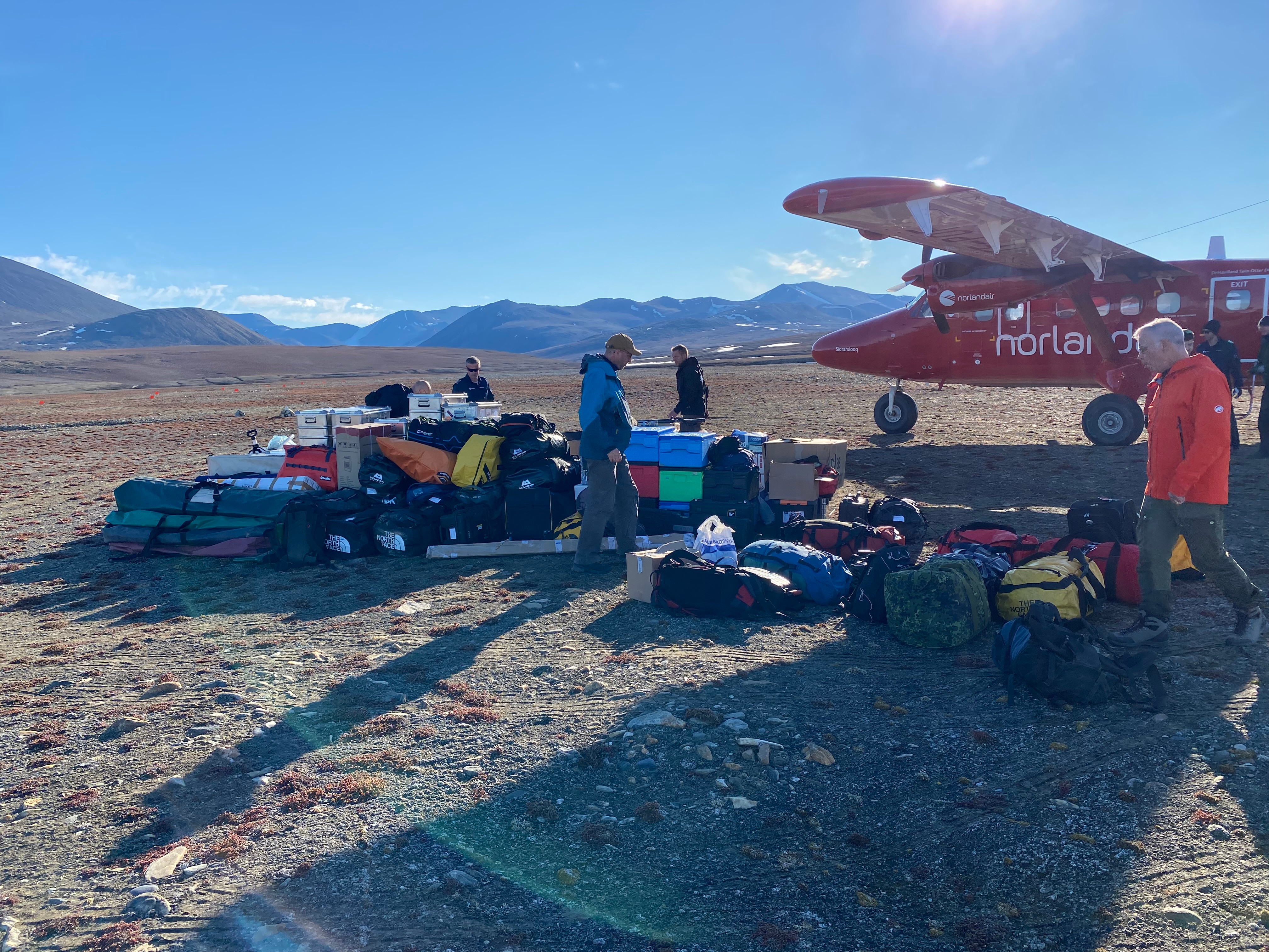
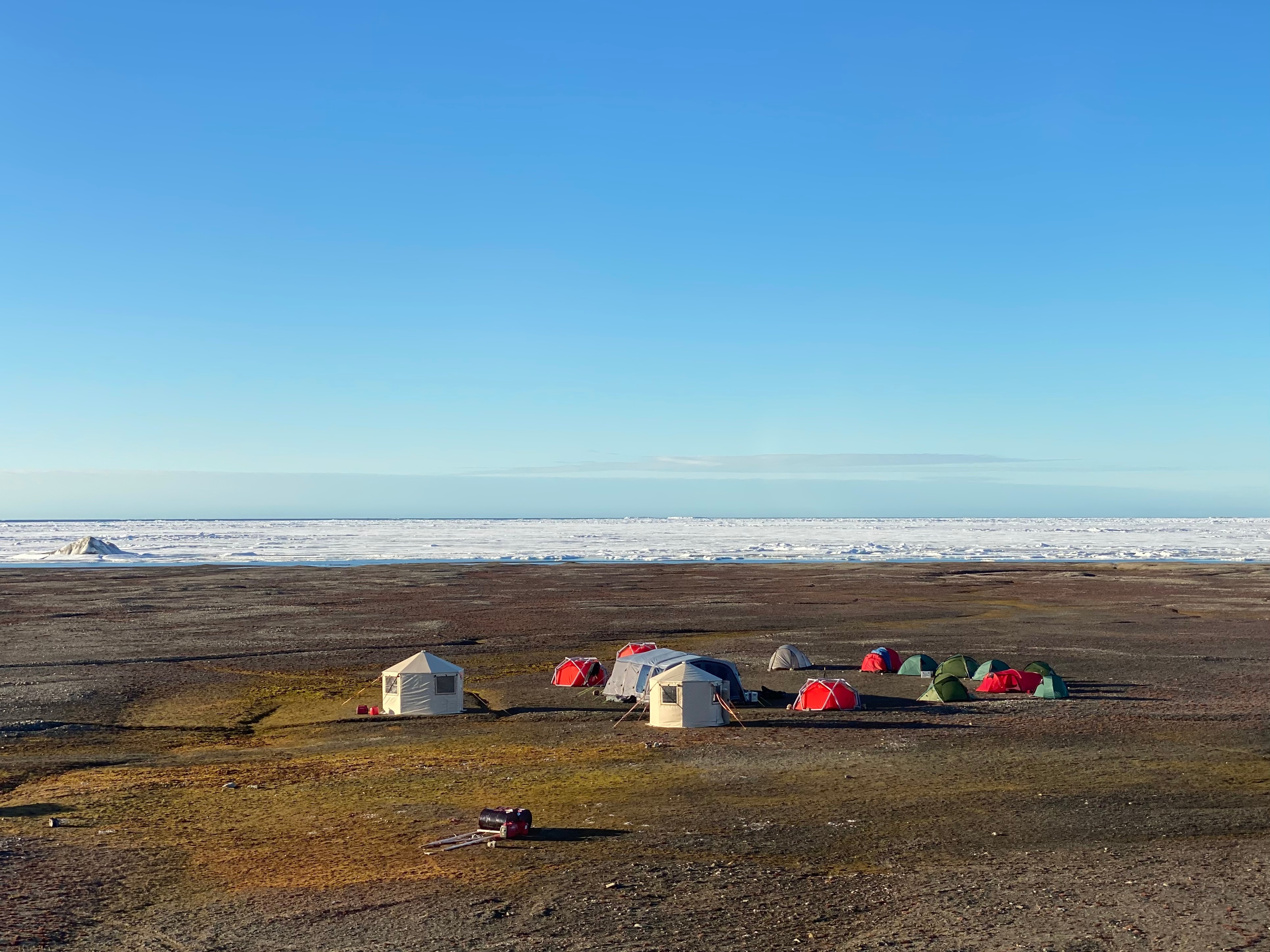
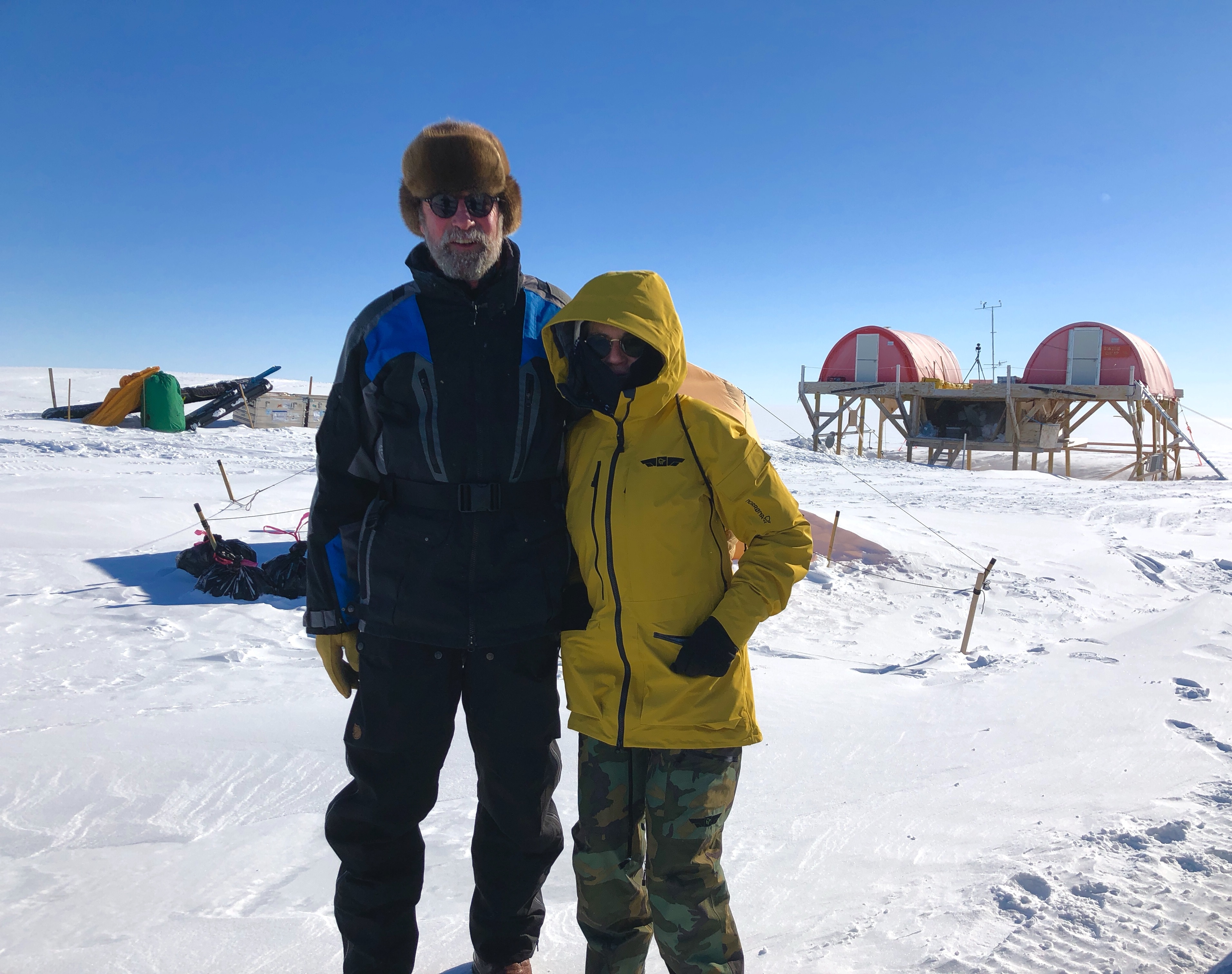
Upon arrival at Cape Morris Jesup, a lot of work awaited the expedition members to set up the base camp.

From the base camp, the destinations for the scientists were organized as day trips or, for longer stays, as fly camps. On August 13, 2022, the base camp was dismantled again. The expedition participants, divided into two groups, flew with stopovers along the coast of North and Northwest Greenland to Qaanaaq, the final destination of the LeisterExpeditionGoNorth2022.

Expedition With Challenges

The effort to organize such an expedition is immense and takes a lot of preparation time. And rarely does everything go according to plan: As Christiane Leister reports, the start of the Leister Expedition Go North 2022 was delayed due to formal requirements and the late arrival of the helicopter because of bad weather conditions. In addition, the scientific leader of the expedition had dropped out due to a medical examination shortly before the start of the expedition, so Christiane Leister took over the coordination of the scientific projects in Greenland as a substitute. “Based on my experience from previous Greenland expeditions and my insights into science as a member of the ETH Board, I managed to coordinate the projects and priorities in such a way that all scientists were able to carry out their sampling and measurements as desired.”

A small cluster of colorful tents and two larger shelters are set up on a flat, brown tundra near the edge of sea ice. The sky is clear and blue, and the camp is surrounded by open, barren land.

This photo shows the base camp of the Leister Expedition Go North 2022 on Cape Morris Jesup. Here, at the northernmost continental tip of our planet, the expedition members spent eleven days in August 2022 at temperatures down to zero degrees. In the background, the view of the Arctic Ocean in direction of the North Pole, which is only 705 kilometers away.

Communication between the expedition participants, the base camp, the fly camps and the scientists while flying to work sites, took place via Garmin inReach satellite communication. These devices were also used to plan and document routes and waypoints.

A digital map interface displays a coastal area with multiple red flag markers and yellow dots connected by light blue lines, indicating tracked routes or waypoints over water and land. The map shows coordinates (N 83.734461°, W 31.317649°), a direction of 359° T, and an elevation of -3 ft. The interface is in German, with options for map, messages, tracking, and compass at the bottom.

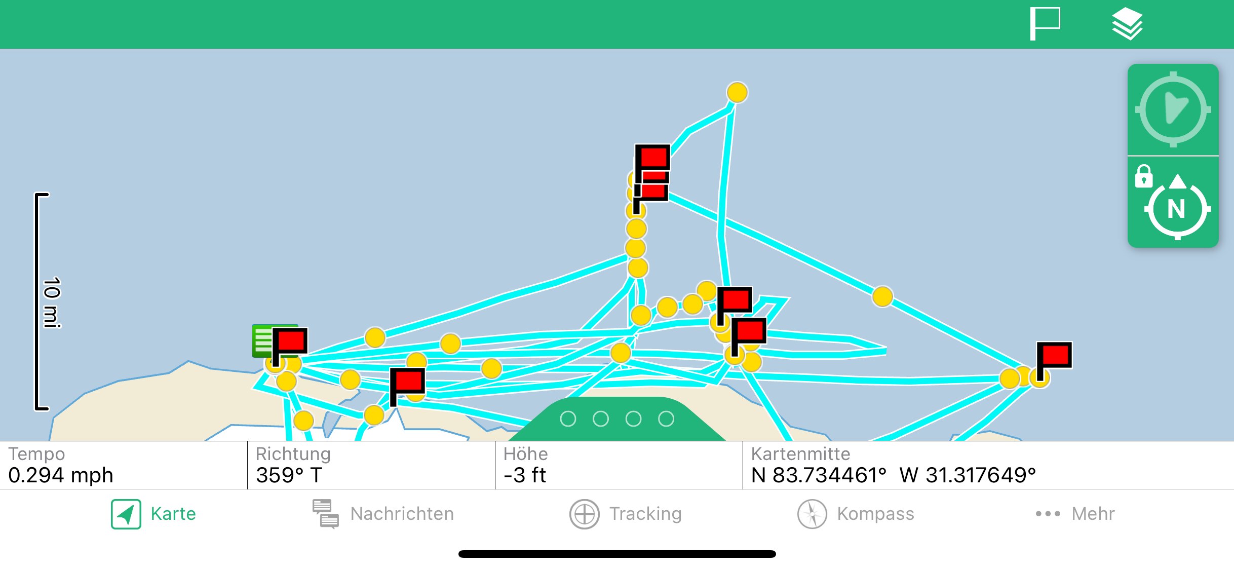
Christiane Leister's waypoints during the expedition in North Greenland. The flags in the Arctic Ocean mark helicopter landings on fast ice, on the two “Leister Islands” and Kaffeklubben.

Glacier Named After Swiss Glaciologist Prof. Dr. Konrad Steffen

Glaciers in Greenland were named in honor of three deceased glaciologists, Niels Ree, Anker Weidick and the Swiss Prof. Dr. Konrad Steffen, former director of the Swiss Federal Institute for Forest, Snow and Landscape Research WSL. This was the first time in a long time that Greenlandic maps were given place names that did not have a Greenlandic origin. The three deceased glaciologists made extraordinary contributions to Greenlandic society and science. Konrad Steffen died in a tragic accident while conducting field research on the ice sheet near Ilulissat in 2020. (Source WSL)

Christiane Leister wanted to visit the “Sermeq Konrad Steffen” during the expedition in August 2022 together with René Forsberg and erect a cairn at the edge of the glacier in memory of Konrad Steffen. Due to difficult wind conditions, it was unfortunately not possible to land there.

A wide glacier winds through a dramatic landscape, bordered by steep, dark cliffs. The glacier’s surface is marked by crevasses and flows toward the horizon, surrounded by snow and ice under a pale blue sky.

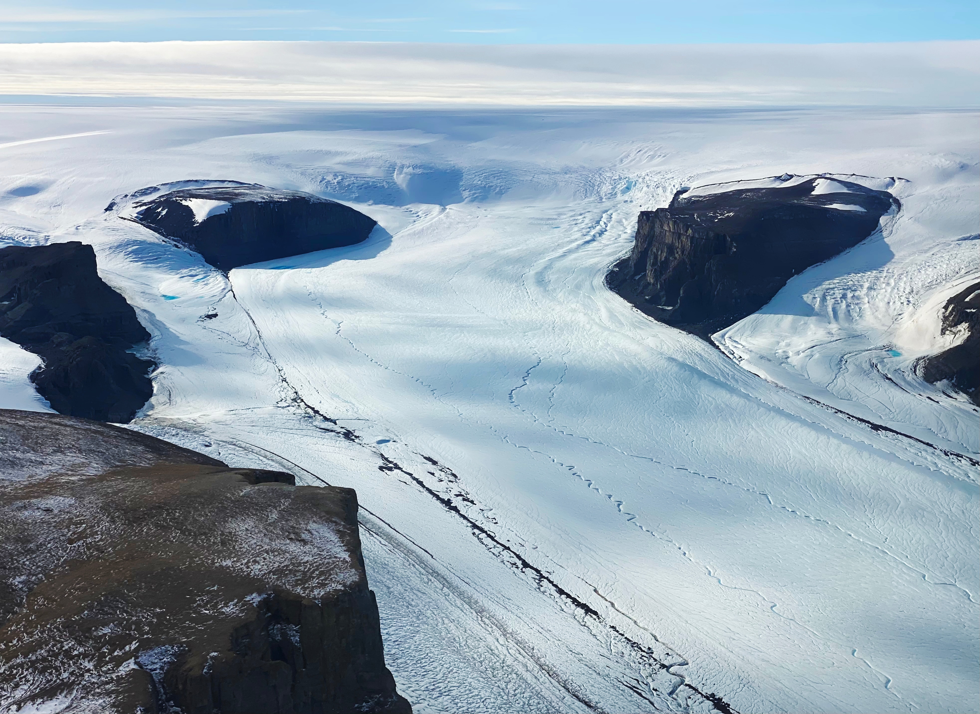
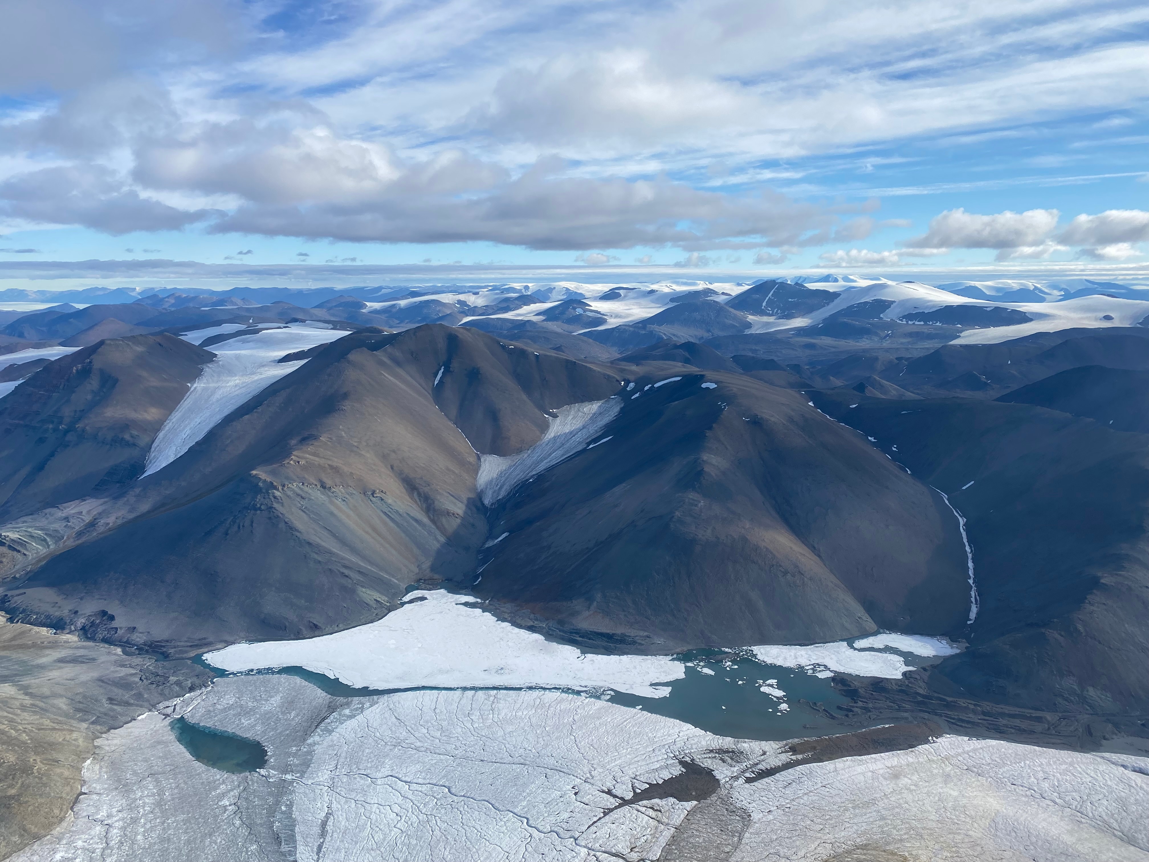
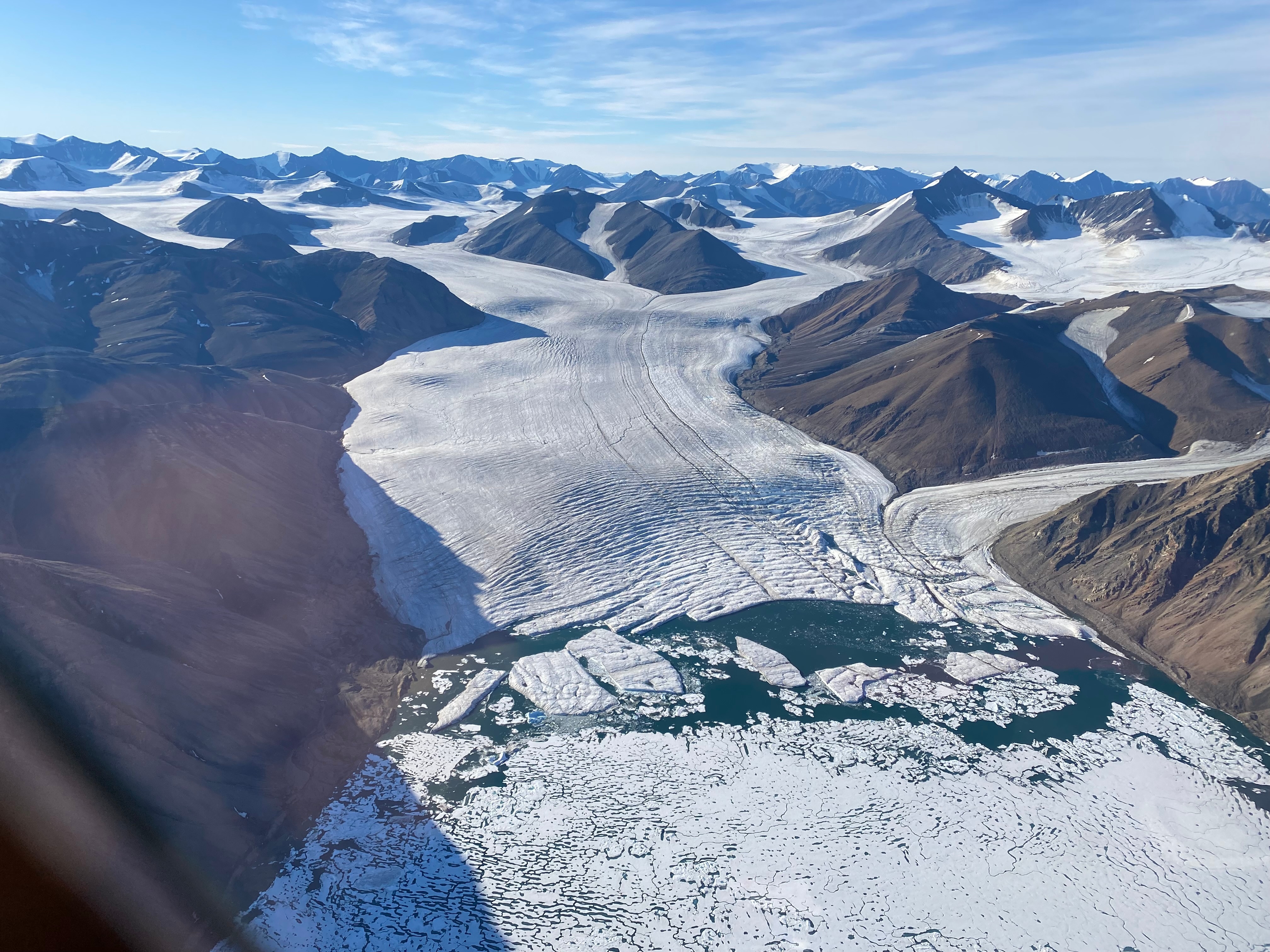
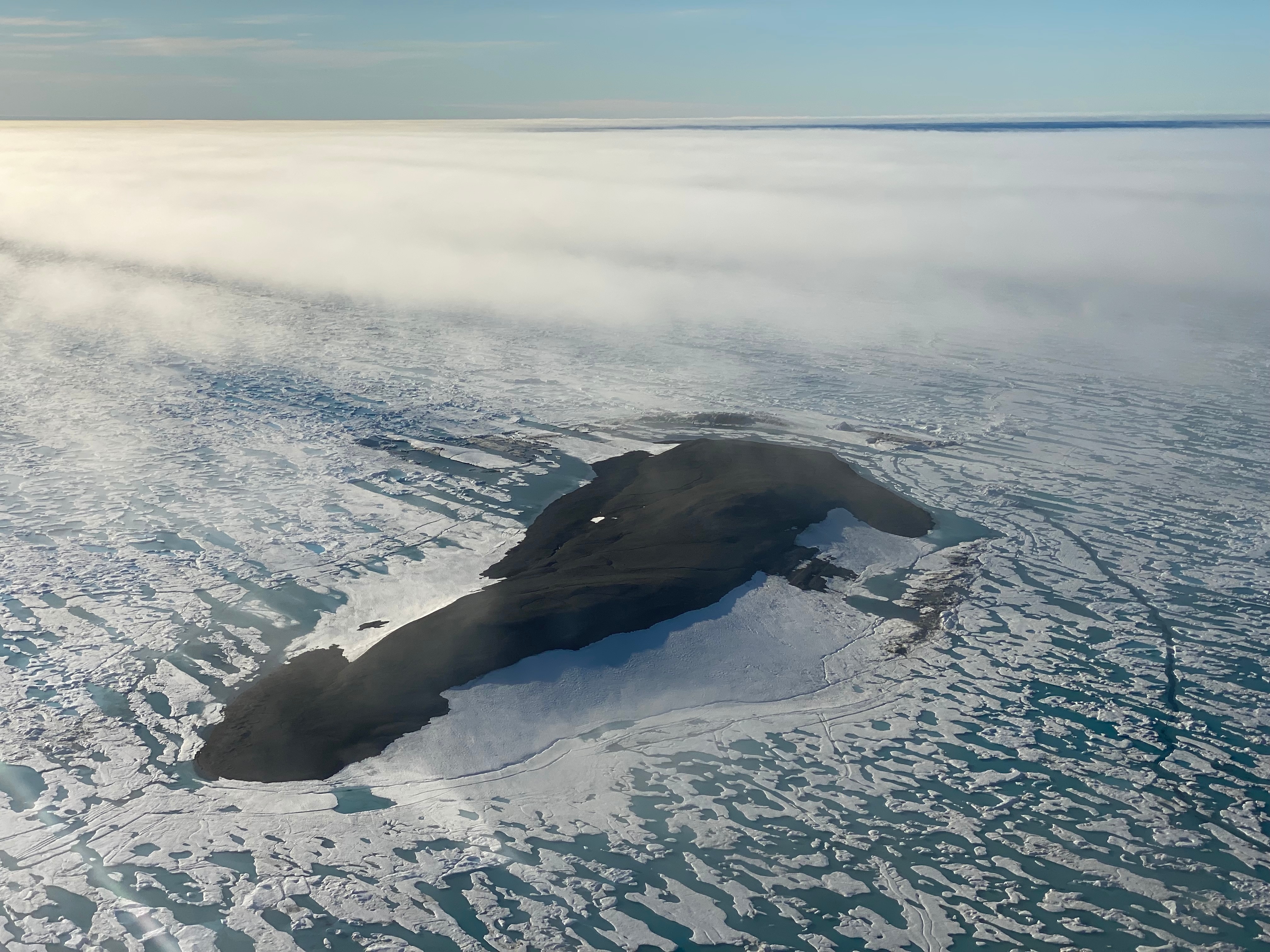
In the picture, you can see the glacier “Sermeq Konrad Steffen” named after Konrad Steffen. The photo was taken by Christiane Leister from a helicopter on August 13, 2022, the last day of the Leister Expedition Go North 2022.

Through her work on the ETH Board and a stay during her 2018 Greenland Expedition at Swiss Camp on the Greenland Ice Sheet, Christiane Leister had a personal connection to Konrad Steffen and held him in high esteem.

Two individuals dressed in insulated jackets and gloves stand together on a snowy landscape. Behind them are two red and white dome-shaped research shelters elevated on wooden platforms, with scientific equipment and supplies scattered nearby under a clear blue sky.

The photo shows Konrad Steffen with Christiane Leister in front of the Swiss Camp. The photo was taken on May 8, 2018, when Christiane Leister visited the research station with her expedition team.

Flowers, Plants and Mushrooms in North Greenland

When we think of Greenland, most of us probably associate it mainly with snow and ice. Yet mosses and lichens, colorful flowers, robust plants and various mushrooms grow in Greenland. During the Leister Expedition Go North 2022, Christiane Leister took some photos of different flowers, plants and mushrooms, which you can see in the following image series.

A cluster of vibrant pink flowers grows on a lush, moss-covered ground, illuminated by sunlight. The scene highlights the contrast between the delicate blossoms and the textured, green moss.

Animals in North Greenland

Greenland is home to various animals such as Polar Bears, Musk Oxen, Caribou, Reindeer, Arctic Foxes, Snow Hares, Snow Grouse, Snowy Owls, Lemmings, Eider Ducks, various bird species and the rarely occurring Arctic Wolf. In addition, Greenland also has insects and butterflies.

During the Leister Expedition Go North 2022, Musk Oxen, Polar Foxes, Polar Bears, a hunting Snowy Owl, Lemmings and several bird species were sighted. In the wet terrain, the expedition participants could also make out several tracks of these animals.

A white Arctic hare with thick fur and upright ears moves across a rocky, uneven surface. The hare stands out against the brown and gray stones, with patches of orange lichen visible among the rocks.

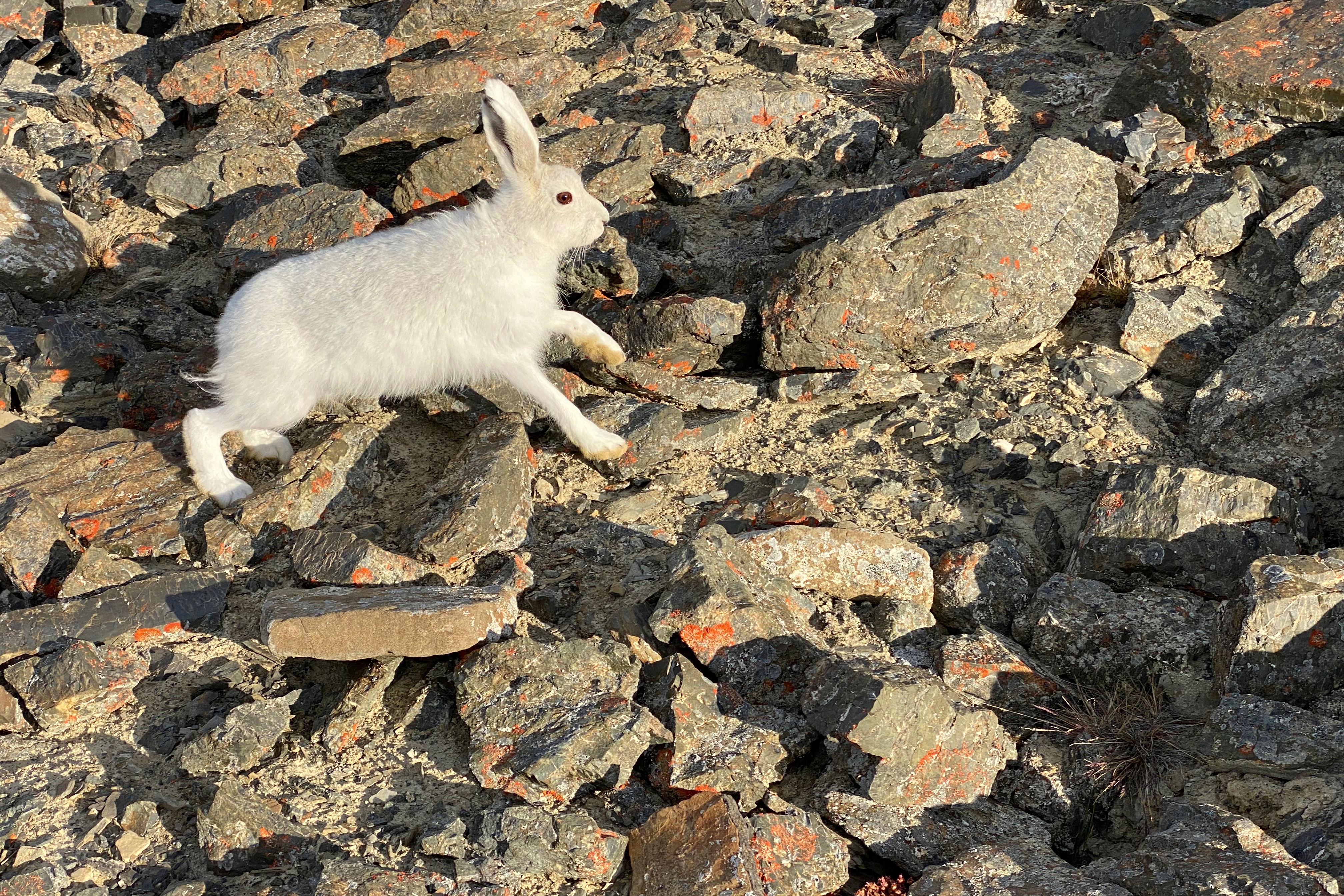
The Snow Hare still wears its white winter coat and travels on the dark scree without camouflage. For better camouflage, its white fur turns gray-brown in summer.

A butterfly with orange and brown patterned wings rests on a patch of rocky, sandy soil. The butterfly’s wings are spread open, displaying intricate markings, and the ground is covered with small stones and bits of orange lichen.

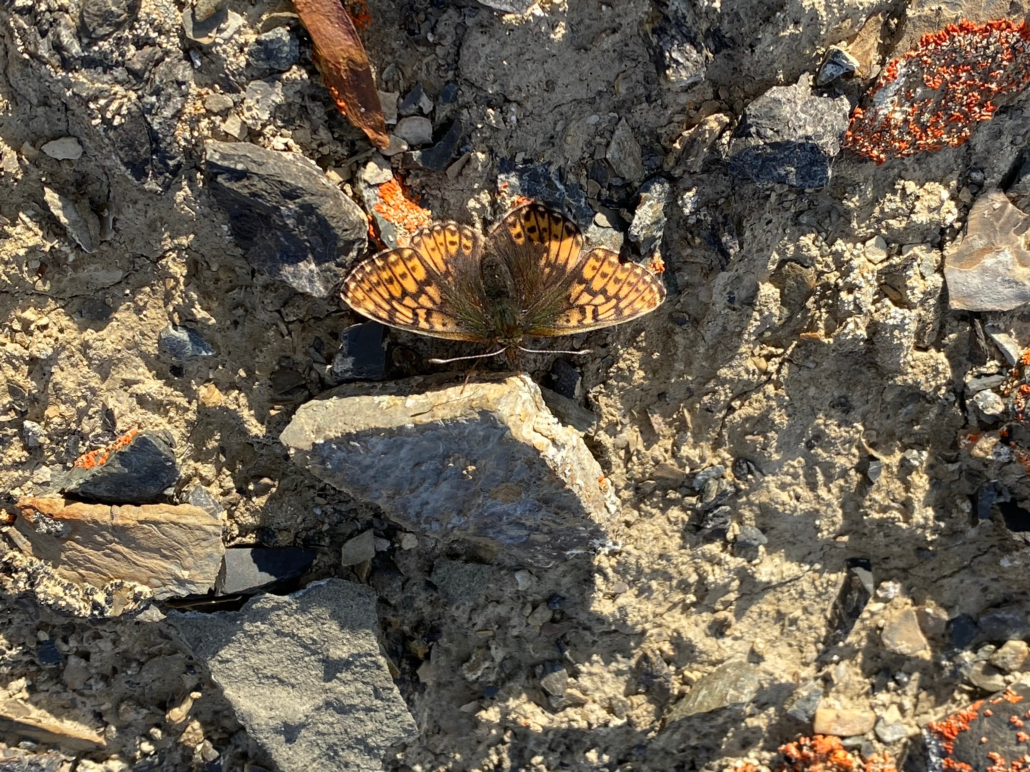
In the photo, you can see an Arctic Pearl Butterfly. This is the most common in Greenland, along with four other butterfly species. It strongly resembles the Polar Pearl-bordered Butterfly, which is native only to the High Arctic North and Northeast Greenland.

Information About the Leister Foundation

Through the Leister Foundation, we are committed to education and science as well as art and culture. Christiane Leister has been fascinated by Greenland for many years. “It is important to me to also initiate and finance scientific research projects in Greenland through the Leister Foundation to support the valuable work of scientists in places that are difficult to access.”

Impressions of the Leister Expedition Go North 2022

In the picture gallery, you will get impressions of the fascinating landscape of North Greenland.

Expansive landscape of dark, rocky mountains interspersed with glaciers and patches of snow. In the foreground, a partially frozen lake is surrounded by ice and snow, with distant mountain ranges stretching under a blue sky with scattered clouds.

Order Book Greenland Expeditions 2021 and 2022 Free of Charge

Would you like to order the book about the Greenland Expeditions 2021 and 2022 for free? Please fill out the online order form. We will send you the book free of charge and free of any obligation.

The cover features an aerial photograph of a glacier curving through a mountainous Arctic landscape, partially covered by clouds. Overlaid text reads: "Leister Expeditions 2021 and 2022. Discoveries and Explorations in North Greenland."